
Sunday 2nd August 2015
I had been waiting for today to arrive ever since I had started to plan this trip. The Preikestolen was featured in the travel magazine I had read in the doctors waiting room, all those years ago. Today, I would hopefully be hiking to the top myself.
Mark and I woke up just before seven. It was raining. It had been raining fairly constantly ever since we had arrived at our hytte yesterday evening. That kind of steady vertical rain, that soaks you through to the skin. If it was going to be another day of crappy weather, then we would have to cancel the hike. There was no point hiking for three hours to see nothing but cloud when we got to the top. One of Mark's friends had done that earlier in the year. Mark has a photo of him on his phone at the top of the Preikestolen, stood in a cloud. It was like the people taking the selfie photos at the Trollstigen.
Mark checked the weather forecast on his phone while we had breakfast. It said it was to be fifteen degrees and sunny with a chance of a shower at 11am. Either the forecaster was on heavy medication, or some kind of biblical act was going to happen in the next couple of hours!
We decided that as we would go and take a look, and make a decision on whether to hike up or not when we got there. We had to travel in that direction anyway.
By the time we had packed up and were ready to set off the rain had stopped. There was even the odd glimpse of the sun shining through. Maybe the gods were on our side after all! We said goodbye to Stuart and Alison and hit the road, Mark nearly in a literal sense. He lost his footing as he turned his bike on the deep pea gravel of the motel driveway. Stuart and Alison were not coming on the hike. They were going to explore the area on their own, and then meet us later in Forsand.
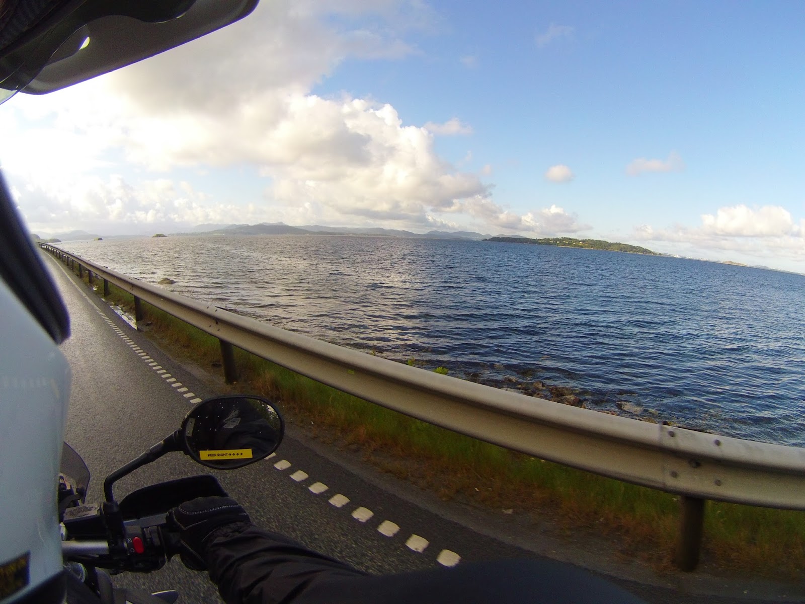
As the E13 climbed out of Hjelmlandsvagen the views over the tiny fjord inlets were like little picture postcard scenes taken straight out of a travel brochure. The sky was bruising, but there was no rain actually falling. It was a very dramatic scene to ride through.


The roads were empty. We had about forty kilometres to ride until we got to the Preikestolen. This is where we were hoping to stop last night. So, we were a little behind the planned schedule. But, I was enjoying the ride a lot more this morning than I would of done in yesterdays rain.


The road started to skirt around the fjords and in and out of a few tunnels. Exiting one of the longer tunnels revealed no sign of the wet weather on the other side. It was warm, the roads were bone dry, and the clouds had all but disappeared.

Signs for the Preikestolen started to appear. It was looking like the hike to the top would be on. I was beginning to bake in my waterproofs. The temperature seemed to be rising a few degrees every few minutes.

The road turned and ran along the shore of the Idsefjord. The water was lapping right up to the edge of the tarmac. If global warming takes hold this part of the E13 will only be open to submersibles.


I pulled over at a service station in Jorpeland. Mark and I fueled up the bikes and I bought some sweets to take with me on the hike. I also had to buy a couple of bottles of water. I had a 2 litre bottle of water netted to the top of my pannier when we left the hytte. But, it was not there now! Mark had not noticed it fall off anywhere, so it must of fell off in one of the dark tunnels.
The sky was looking angry again as we left Jorpeland. A long line of cloud that stretched across the sky and had deposited its contents as it had passed over. But, it seemed to be moving at a similar pace to us, as we never managed to catch it up. The sun was bright in the sky. I just hoped it would burn the cloud away.

As we approached the turn off for the road to the Preikestolen our first bit of traffic appeared on the horizon. It seems that the caravan clan will find you wherever you are!

When we arrived at the Preikestolen the carpark was beginning to fill up. We followed the signs for the motorcycle parking where a Honda ST1300 and a BMW R1100GS were parked up. The motorcycle parking was at the end of the coach parking area where lots of Korean and Japanese tourists were being organized into groups by their tour guides.
I changed out of my riding gear, and into some lighter clothing and my hiking shoes. I ran a cable lock through my riding gear and locked it to my bike. I took my valuables with me in my backpack. Even though I was now used to just leaving everything on my bike, and returning to find it untouched, I was a little uneasy at leaving it for the three or four hours we would be hiking. Security guards were walking around in the carparks too. But, I just couldn't leave my things.
Mark just changed his boots into some lighter ones. He was going to walk up in his bike gear. Being a ruffty tuffty northerner, and a lot fitter than me, he thought he would be fine!
The path up to the top of the Preikestolen was very well sign posted. It started with a gravel path which climbed quite steeply out of the carpark.
I had been waiting for today to arrive ever since I had started to plan this trip. The Preikestolen was featured in the travel magazine I had read in the doctors waiting room, all those years ago. Today, I would hopefully be hiking to the top myself.
Mark and I woke up just before seven. It was raining. It had been raining fairly constantly ever since we had arrived at our hytte yesterday evening. That kind of steady vertical rain, that soaks you through to the skin. If it was going to be another day of crappy weather, then we would have to cancel the hike. There was no point hiking for three hours to see nothing but cloud when we got to the top. One of Mark's friends had done that earlier in the year. Mark has a photo of him on his phone at the top of the Preikestolen, stood in a cloud. It was like the people taking the selfie photos at the Trollstigen.
Mark checked the weather forecast on his phone while we had breakfast. It said it was to be fifteen degrees and sunny with a chance of a shower at 11am. Either the forecaster was on heavy medication, or some kind of biblical act was going to happen in the next couple of hours!
We decided that as we would go and take a look, and make a decision on whether to hike up or not when we got there. We had to travel in that direction anyway.
By the time we had packed up and were ready to set off the rain had stopped. There was even the odd glimpse of the sun shining through. Maybe the gods were on our side after all! We said goodbye to Stuart and Alison and hit the road, Mark nearly in a literal sense. He lost his footing as he turned his bike on the deep pea gravel of the motel driveway. Stuart and Alison were not coming on the hike. They were going to explore the area on their own, and then meet us later in Forsand.
As the E13 climbed out of Hjelmlandsvagen the views over the tiny fjord inlets were like little picture postcard scenes taken straight out of a travel brochure. The sky was bruising, but there was no rain actually falling. It was a very dramatic scene to ride through.


The roads were empty. We had about forty kilometres to ride until we got to the Preikestolen. This is where we were hoping to stop last night. So, we were a little behind the planned schedule. But, I was enjoying the ride a lot more this morning than I would of done in yesterdays rain.


The road started to skirt around the fjords and in and out of a few tunnels. Exiting one of the longer tunnels revealed no sign of the wet weather on the other side. It was warm, the roads were bone dry, and the clouds had all but disappeared.

Signs for the Preikestolen started to appear. It was looking like the hike to the top would be on. I was beginning to bake in my waterproofs. The temperature seemed to be rising a few degrees every few minutes.

The road turned and ran along the shore of the Idsefjord. The water was lapping right up to the edge of the tarmac. If global warming takes hold this part of the E13 will only be open to submersibles.

I pulled over at a service station in Jorpeland. Mark and I fueled up the bikes and I bought some sweets to take with me on the hike. I also had to buy a couple of bottles of water. I had a 2 litre bottle of water netted to the top of my pannier when we left the hytte. But, it was not there now! Mark had not noticed it fall off anywhere, so it must of fell off in one of the dark tunnels.
The sky was looking angry again as we left Jorpeland. A long line of cloud that stretched across the sky and had deposited its contents as it had passed over. But, it seemed to be moving at a similar pace to us, as we never managed to catch it up. The sun was bright in the sky. I just hoped it would burn the cloud away.

As we approached the turn off for the road to the Preikestolen our first bit of traffic appeared on the horizon. It seems that the caravan clan will find you wherever you are!

When we arrived at the Preikestolen the carpark was beginning to fill up. We followed the signs for the motorcycle parking where a Honda ST1300 and a BMW R1100GS were parked up. The motorcycle parking was at the end of the coach parking area where lots of Korean and Japanese tourists were being organized into groups by their tour guides.
I changed out of my riding gear, and into some lighter clothing and my hiking shoes. I ran a cable lock through my riding gear and locked it to my bike. I took my valuables with me in my backpack. Even though I was now used to just leaving everything on my bike, and returning to find it untouched, I was a little uneasy at leaving it for the three or four hours we would be hiking. Security guards were walking around in the carparks too. But, I just couldn't leave my things.
Mark just changed his boots into some lighter ones. He was going to walk up in his bike gear. Being a ruffty tuffty northerner, and a lot fitter than me, he thought he would be fine!
The path up to the top of the Preikestolen was very well sign posted. It started with a gravel path which climbed quite steeply out of the carpark.

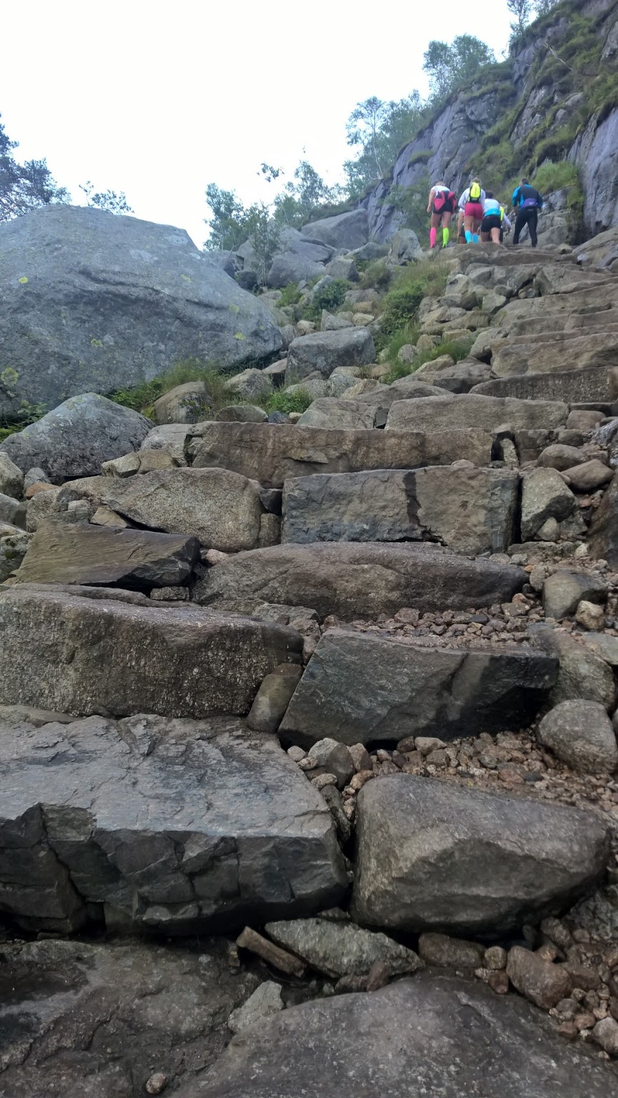
A few hundred metres later a series of large boulder step led the path up through the forest. Pretty soon we were high above the carpark from where we had started. I was puffing a bit already, and we had over two and a half kilometres to go!


The path then began to drop slightly as it followed a stone walkway through a bit of a valley. There were a few other hikers about. But, pretty soon we had passed them and were on our own.

At the other side of the valley it was time to climb again. A bit of effort was required to navigate up the large boulder steps. Just to highlight my lack of fitness, a group of young lady runners in bright coloured lycra sprinted pass. Mark turned round grinning, and signaled for me to chase them. But, I was in no fit state. It was hard enough walking up!

Once over the boulders things flattened off a little. A boardwalk crossed a marsh and I managed to get my breath back a little. It was getting quite warm now that the sun was high in the sky.

Reaching a huge rockface, more rock steps led the way up. The group of young ladies had stopped for a breather, and we had caught them up. We were now faced with having to follow the lycra clad lovelies up the next few sections!

At the top of the rocks a huge plateau appeared. A sign indicated that we were now half way up. We stopped for bit of a break. Mark was beginning to regret bringing his jacket. A young guy in a Manchester United shirt came jogging past. "There is always one idiot wearing one!" I said to Mark. I think the guy heard me. We bumped into him a little further up the trail. He was English. He and his friend were climbing up some of the cliff faces to get a better view of the valleys below.


The rest of the path up to the top seemed to go a little easier. A walkway bolted to the cliff with just a chain hand rail to stop you plummeting to your death, was the only concession to health and safety. Within sight of the top the young lady runners zoomed by on their way back down. One of them had taken a tumble and was covered in mud all down her left side.
The views from the top were incredible. The Preikestolen has a 25 x 25 metre flat square top with a almost shear 604 metre drop down to the fjord below. There were a few people braving the edge to look over at the drop. Everyone wanted their picture taken near the edge.


I took the obligatory selfie shot. I also took a couple of shots sat on the edge with my feet hanging in the breeze. It did look a long way down!


At 11am a few spots of rain fell from the sky. And it was just that, a few spots. So far the weather had been absolutely perfect. After about half an hour of taking photos, it was time to head back down again. I spied Mark taking a selfie. Following his attempt to photobomb my selfie in front of the snow wall a few days ago, I though I would get my own back. But, as I leapt into shot I slipped and rolled across the floor, ending up in a muddy patch! I now looked like the girl runner earlier with mud all down my left arm. Mark was more concerned that I had landed about 18" from the edge of the drop!
Coming down the path was harder than going up. The rock steps seemed bigger going down. We also had to contend with swimming against the tide. As it was now past 11am, the whole of Norway seemed to be making its way up to the Preikestolen. Carrying babies and small dogs seemed to be popular. Immaculately dressed Japanese tourists were among them with not a speck of mud on their beige chinos.
By the time we got back to the bikes, I was soaked in sweat. I went off to the toilet block to wash up and get changed. I bought an icecream from the gift shop. Mark downed a huge bottle of water. I stuck one of my stickers on the parking meter where there were a few others from all over Europe. We then fired up the bikes and made our way out of the carpark.
We rode back the way we had come in. It was then we realized that this avoided the carpark barriers. We had paid to park, as you needed the ticket to open the barrier as you left the carpark. We were now on the other side of the barriers, and so could of got away without paying. I wondered how many others had done the same!
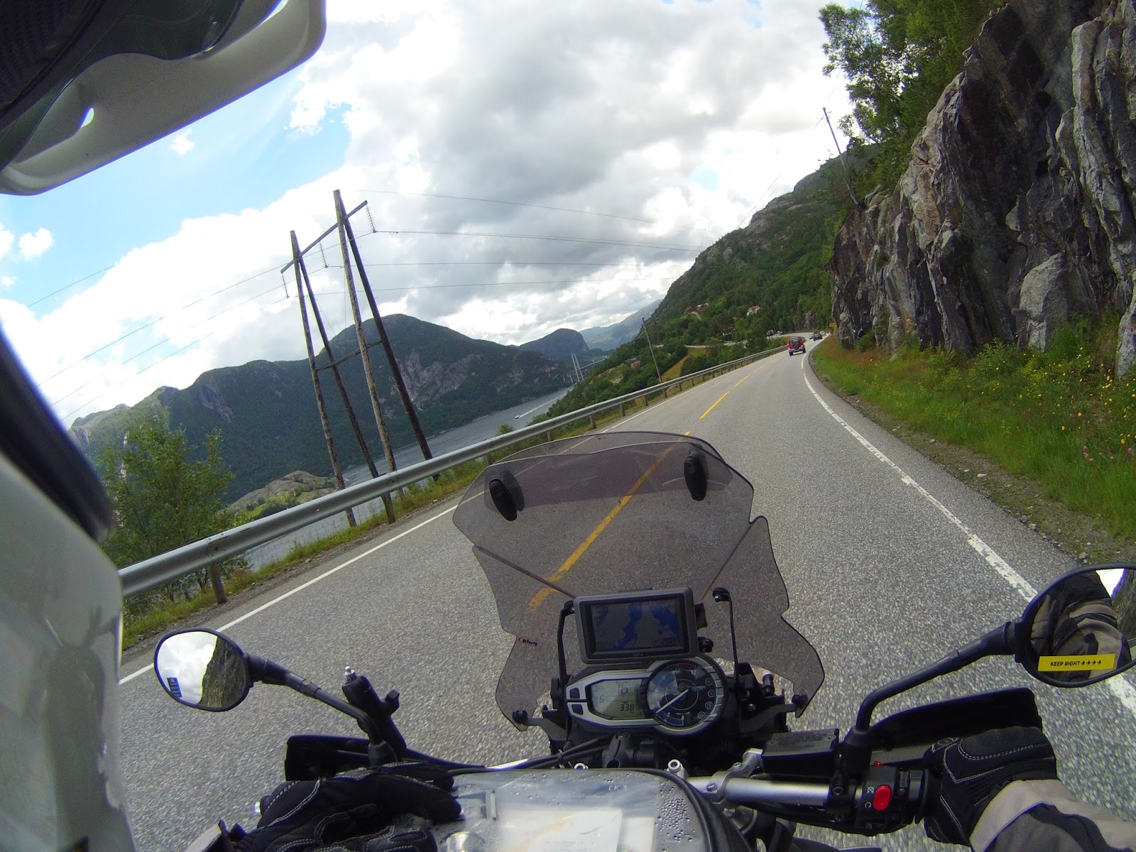
Back on the E13, we headed for Forsand. Here we would catch the ferry along the fjord to Lysebotn. It was great to be riding along in the sunshine again.
There was one of the expedition trucks spotted in the Nordkapp carpark, parked up in a layby. I really love these things. Maybe one day!


Forsand is on the other side of the fjord from the E13 ferry dock. The road crossed an impressive suspension bridge, and wound its way down to the edge of the fjord.


I spotted a wood merchant just before the dock which had a huge wooden hammer mounted on the roof. It was like something you would see on Route 66.

At the ferry dock, a few cars and campervans were waiting in a queue. We, of course, rode straight to the front. We had just over an hour to wait for the ferry. The tourist ferry only runs twice a day. Once early in the morning, and the one we were catching mid-afternoon. There was also a fast ferry. This needed to be booked 24hrs in advance due to the limited vehicle space. Stuart and Alison arrived half an hour after us and we had a catch up on each others mornings. I got chatting to an older German guy who was travelling around in his VW camper with his son. He was heading for the Lofoten Islands, and was keen to hear my opinion. I told him it was definitely worth the trip.
The ferry arrived and once we were all aboard, we made our way up to the passenger deck. The ferry takes two and a half hours to travel to Lysebotn, making a few stops along the way. There were screens telling you where the ferry was, and what points of interest were approaching. A voice over also told you information at each of these points. I quite enjoyed it.
We passed under the suspension bridge we had crossed on the ride to Forsand. I seemed a long way up form the deck of the ferry.


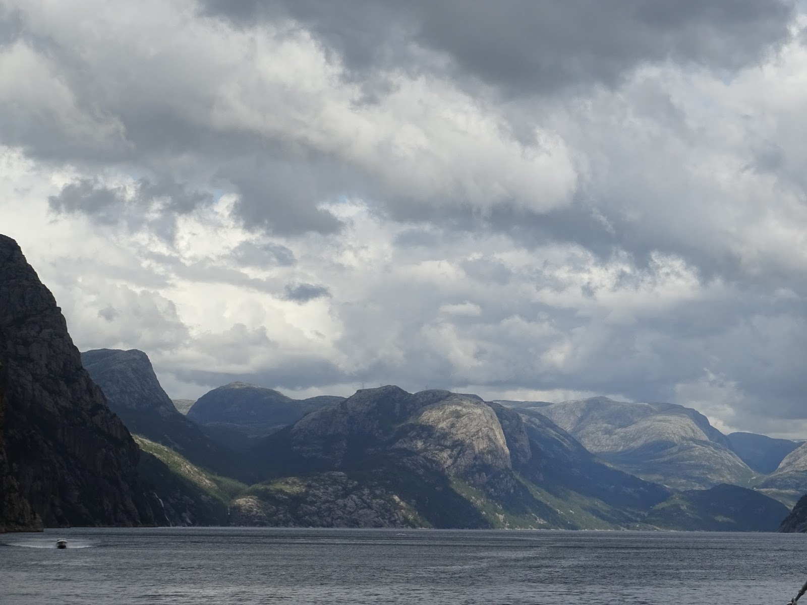
The fjord and the surrounding mountains were constantly changing colours as the sunlight broke through the clouds. I was feeling a little peckish from this morning exertions, so I headed for the cafeteria. A hotdog, coffee, and a piece of Diam cake seemed appropriate. The nice lady on the till, scanned through my handful of change and took all the smaller shrapnel. She didn't want to take all the bigger more, useful coins which was nice of her.
About forty minutes into the journey the ferry sailed under the Preikestolen. You really got a sense of how high it was. At thirty times zoom on my camera I could just make out the silhouettes of the people up on the top where Mark and I had been. There were a few brave souls lying on their bellies and looking over the edge. You could see their faces appear every now and then. I didn't see any feet though!


One of the stops the ferry made was to an old hydro-electric plant. It is now a museum, coffee shop and B&B. You could even walk up the thousands of steps that run to the top of the mountain along side the supply pipeline. Maybe another day.

As we got towards Lysebotn the ferry passed the Kjeragbolten. This is a huge boulder that is wedged in the gap between the two surrounding cliffs. People leap onto the boulder to have their photos taken. There was nobody standing on it as we sailed by. But, several basejumpers leapt from the top of the cliff next to it, before parachuting down to near the waters edge.

The end of the fjord was in sight and soon we arrived in Lysebotn.

I got ready to depart in plenty of time. Our bikes were at the front and so we should be off first. There was a long queue of traffic waiting to board as we arrived. But, it seemed odd that they were all parked on the wrong side of the road.


The deckhand held all the other traffic back, and waved us off. Just as I got to the outskirts of the village I realised that I had forgotten to fasten my helmet strap. I had to pull over. I waved Mark and Stuart passed and pulled over into a gateway. As I was sorting my helmet strap, all the cars started streaming past. Balls!
I knew that the first part of the road out of the village was a tight twisty hairpin road. But, being on a bike I could usually get passed any slower traffic. Not when the car drivers insist on driving at 30kph down the middle of the road, though. Realising I was not going to get by, I pulled over for a few minutes and let them go.
I set off again up the mountain, only to catch the back of the queue almost immediately as the cars ground to a halt in a tunnel. Double Balls! Right, I needed to be a bit more forceful then. I started picking the cars off one at a time. Just before the top I had managed to get to the front and enjoy the clear road winding its way over the mountain. At the Eagle Nest viewing point at the top, I scanned the carpark for Mark and Stuart, but I was not planning on stopping. The road out of Lysebotn is the only road, so there was no chance of us getting lost. I planned on riding to the junction at the end and waiting for the others there.
I started to get in to a nice rhythm, with one bend leading into the next. It was an amazing piece of road. And it seemed never ending. There was the occasional car to contend with, but it was virtually deserted.
I was really enjoying myself when suddenly, I overshot a corner. Approaching a left hand bend, a dip in the road made my centre stand bottom out. This stood the bike up and it started to run wide. I began to brake and could see the huge granite rock face on the outside of the corner fast approaching. I am thinking that this is where my holiday ends. Along with my existence! Triple Balls!
But no. I relaxed my grip on the bars, stood on the pegs, and steered my bike along the thin expanse of gravel between the tarmac and the rock face. It dawned on me that I was in control. I AM A RIDING GOD! With that I got the bike back onto the tarmac, and I was on my way again. Slightly more sedately. Counting my blessings I pulled over for a breather and to take in the view.

With my heartrate back to below crisis level I rode on. But, I don't get far. Every blind crest, and every bend presents another photo opportunity. This place was like another world. The views were endless. There was no noise, and only a gentle breeze blowing. I could of ridden this road for a week.


I heard a familiar rumble and Stuart and Alison pulled up. They had stopped at the Eagles Nest, and said Mark carried on up the road. We carried on the junction a few kilometres further on to find Mark waiting with a big grin on his face.

This is where Mark and I would leave Stuart and Alison. They had a ferry to catch from Stavanger the following day. Mark and I still had two more days in Norway. So after saying goodbye, Mark and I set off east towards Telemark.

The road continued in a similar way to the previous thirty kilometres. Stunning scenery, and an empty ribbon of tarmac stretching for miles across the mountains. There were a few cabins hidden away up on the lower slopes. Some of them were ski resorts with a lift system.


Ten kilometres along, the road turned sharply as a huge dam had been built at the end of a fjord. From the size of it there must of been quite a body of water on the other side.


The road eventually joined up with the FV9. We headed south in the direction of Rysstad. The tarmac was brand new. I was loving the ride this afternoon.


At Rysstad Mark stopped at a garage and bought some oil for his bike. I suggested looking for somewhere to stay for the night. A few kilometres later we spotted a sign for a campsite at a very posh looking hotel complex. We scored a hytte for 590NOK. The hytte was in a great location down by the water, at the foot of a large mountain. I made use of the washing machine and dryer, as I now had a bag full of muddy, sweaty clothes from this morning. The facilities were in the main hotel, and were very upmarket compared to what we were used to. I felt a little out of place walking in there looking like the great unwashed.


I took a wander around taking a few photos after dinner. The fjord had a swimming pond in it surrounded by a stone wall. It looked inviting but the water nearly froze my fingers off when I tested the temperature. I never did see anyone go for a swim in it.


Here is part 17 of my vlog:
No comments:
Post a Comment